Skip to content
AV ScannerNews
FeedMapAreasScanner Codes
Submit a Tip
LIVE5 posts today · Latest: Significant Sentencing Update 🚨⚖️ This morning, Pablo Garcia Perez was sentenced to…Synced 13m ago
AV Scanner News

Antelope Valley's source for real-time incident tracking, scanner codes, and community news.

admin@avscannernews.com
Get the app
Download on theApp StoreGET IT ONGoogle Play

Categories

  • Crime
  • Accident
  • Community
  • Missing Person
  • Fire
  • Traffic
  • Weather
  • General

Quick Links

  • Contact Us
  • Latest Posts
  • Scanner Codes
Lancaster Sheriff Station(661) 948-8466Palmdale Sheriff Station(661) 272-2400City of Lancaster(661) 723-6000City of Palmdale(661) 267-5100CHP After Hours(323) 259-3200CHP AV(661) 743-6060

© 2026 AV Scanner News. All rights reserved.

PrivacyTermsBuilt by Kernforge
FeedMapCodesTip
← BACK TO FEED
Weather

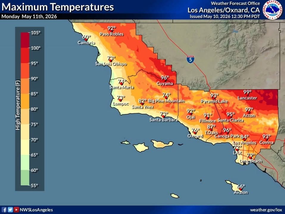
Warm and dry weather is expected to continue through Tuesday. At this time, Monday looks to be the warmest day with high temperatures climbing into the 88-102 range…
Sun, May 10, 2026 · 2:47 PMNO LOCATION EXTRACTED
Warm and dry weather is expected to continue through Tuesday. At this...

Warm and dry weather is expected to continue through Tuesday. At this time, Monday looks to be the warmest day with high temperatures climbing into the 88-102 range away from the coast. The persistent marine layer influence (the morning low clouds and fog) will keep the coastal plain cooler.

With the warm and dry conditions, fire weather will be a growing concern. Currently, elevated to brief critical fire weather conditions are expected across interior sections (foothills, mountains and deserts) through Tuesday. The combination of low relative humidity (6-20%), warm temperatures, south to southwest winds (gusts 25-45 MPH) and drying vegetation will bring the elevated to brief critical fire weather conditions.

For Wednesday through Friday, conditions will moderate with cooler temperatures and higher relative humidity

More in Weather
6:55 PM15h agoWeatherAn extended period of high temperatures is expected this coming week, hottest……Thursday through next Monday. Interior highs will be 98-108 with warm overnight lows. Heat Advisories are in effect for most areas away from the immediate coast, with an Extreme Heat Warning for the Antelope Valley. Use extra caution during this time, check on others and remember: never leave kids or pets in a parked car. Also not a great time to hike with your dog!1:08 PM6d agoWeatherHot conditions with elevated risks for heat illness continues through Thursday, generally……peaking today. Find ways to stay cool, especially this afternoon. Water is your friend (stay hydrated and take a dip to cool down). Improved conditions expected by Friday3:07 PM7d agoWeatherHigh Fire Weather Risk Wednesday through Thursday. Stay alert. Listen to advice……from emergency officials. Be careful with anything that can spark a fire
SourceView original post on Facebook
PostedMay 10, 2:47 PMImportedMay 10, 3:00 PMCategoriesAuto · WeatherLocationNot extracted